East River Bridges

Bronx Bridges
Few people realize that New York City has over 2,000 bridges. We traverse these bridges on subways and railroads, as motorists, bicyclists, and pedestrians. Bridges are found in our parks, over roadways, and over our waterways.
The Harlem River bridges feature eight bridges built between 1842 and 1910. Connecting the mainland Bronx to Manhattan, the Harlem River has the largest river concentration of the city’s oldest surviving bridges.
We are most conscious of the full range of the Harlem River bridges when we ride Metro North’s Hudson railroad line, or when we take the Circle Line’s excursion boat. The railroad and boat offer the best opportunity to closely examine and appreciate the construction details of these bridges.
The East River bridges form an important link connecting highways east with Long Island and west to New Jersey, upstate New York and New England. Our East River suspension bridges offer stunning views of Long Island Sound, the Manhattan skyline, and portions of the outer boroughs of the Bronx and Queens.
All waterway bridges presented on this site have interesting features and are vital links in the city’s transportation system. They are managed today by either the N.Y.C. Department of Transportation (DOT), the N.Y.C. Department of Parks and Recreation (DPR), Amtrak, or the MTA Bridges and Tunnels Authority (MTA)
East River Bridges
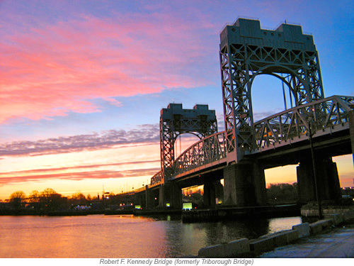
Robert F. Kennedy Bridge (formerly Triborough Bridge)
Connects the Bronx, Manhattan and Queens via the consolidated Ward’s, and Randall’s Island
Maximum span: (a) 1,380 feet; (b) 383 feet; (c) 310 feet. Length: (a) 2-1/3 miles; (b) 1683 feet; (c) 770 feet. Height: (a) 143 feet; (b) 55 feet; (c) 55 feet lowered, 135 feet raised
Engineer: Othmar H. Ammann; architect: Aymar Embury II
Opened: 1936. Three steel bridges: (a) suspension bridge over East River;
(b) truss bridge over Bronx Kills; (c) vertical lift bridge over Harlem River
Operated by MTA (formerly TBTA)
The bridge’s groundbreaking ceremony was held on October 25, 1929 or Black Tuesday, the inauspicious day of the stock market crash. Prepatory work on bridge construction limped ahead but halted when city funding dried up and the nation was in the throes of the Great Depression. WPA funds from Franklin Roosevlt’s New Deal program ultimately saved the project. The newly created Triborough Bridge Authority, with Robert Moses at the helm, moved the construction into high gear. Moses and his staff streamlined the expensive bridge plans, cut costs and managed to complete construction in two years. The Triborough managed to link three New York City boroughs via suspension, truss, and vertical lift bridges, along with long viaducts and the linking of a complicated network of traffic intesections and highways. It also achieved Robert Moses dream, to link the city’s parks and recreational facilities.
In 2008, the bridge was renamed the Robert F. Kennedy Bridge. This renaming honors New York’s former U.S. Senator and commemorates the 40th anniversary of his assassination.
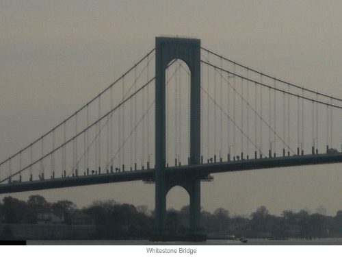
Bronx - Whitestone Bridge (commonly called The Whitestone)
Connects: Hutchinson River Pkwy. & Ferry Point Pk. (Bronx) to Cross Island Expwy & Whitestone, and Malba (Queens)
Maximum span: 2,300 feet; length: 3,770 feet; height: 150 feet
Engineer: Othmar H. Ammann; and Cass Gilbert & Co. (architects)
Opened: 1939 (suspension bridge); operated by: MTA (formerly TBTA)
Robert Moses helped secure private financing for this bridge and wanted it ready for the opening of the 1939 World’s Fair in Flushing Meadow Park. He fast tracked construction, completing the project ahead of schedule, in just 23 months. Both the Bridge and the Fair, in fact, opened on the very same day. Before the Whitestone was built, the only bridge linking the Bronx and Queens was the congested Triborough Bridge (now Robert F. Kennedy Bridge), five miles to the south. Opening of the Whitestone facilitated transportation between Long Island, upstate New York, New England, and New Jersey. It also fit in with Moses’ Belt Parkway system around Brooklyn and Queens, and as a connection to LaGuardia Airport (then North Beach Airport).
The bridge is notable for its clean, graceful lines. It was the 4th largest suspension bridge in the world when it opened. It was designed with two 377 foot towers, no diagonal cross bracing and no stiffening truss system. Instead it had I-beam girders which gave it an art deco look. The failure of the larger, but similarly designed Tacoma Narrows Bridge (Washington) led to changes in the Whitestone’s construction so that it would be more aerodynamically stable. To reduce oscillation, stay cables were added to the towers, lanes were widened, and trusses were added to both sides of the deck. By 2003 technology and materials were much improved. Lightweight fiberglass fairing improved the aerodynamic profile by slicing the wind passing over the bridge. These improvements allowed for the removal of heavy deck trusses. The overall effect was a strengthened and more aesthetically pleasing bridge, closer to its original design.
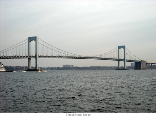
Throgs Neck Bridge
Connects Throggs Neck, Locust Point, Fort Schuyler (Bronx) to Beechurst, Bayside, Little Bay Park, Fort Totten (Queens)
Maximum span: 1,800 feet; length: 13,410 feet ; height: 142 feet
Engineer: Othmar H. Ammann
Opened: 1961 (suspension bridge); operated by MTA (formerly TBTA)
This bridge is the newest span across the East River and takes its name from John Throckmorton, who settled in what is now the Throggs Neck area of the Bronx in1643. In naming the bridge, Robert Moses felt that one “g” in Throggs was preferable for signage.
For this project, Moses again selected Ammann, who had designed the earlier Bronx –Whitestone Bridge, as well as the George Washington, and Triborough bridges. This suspension bridge had two 360 foot high towers. After his previous experience with aerodynamic issues on the Bronx-Whitestone, Ammann returned to using stiffening trusses under the bridge’s deck in order to weight it down and counteract wind blowing at instead of through the bridge.
The Throgs Neck Bridge faced community opposition in both the Bronx and Queens when it was originally proposed. Residents were less concerned about the benefits of job creation as they were about the overall effect of the bridge on quality of life issues in their communities. When opened, this bridge almost immediately relieved congestion on the Bronx-Whitestone Bridge. Within a few years, both bridges were carrying increased numbers and in almost equal proportion. The bridge today plays a critical role in feeding the interstate highway systems of Long Island, the Bronx, upstate New York, New England and New Jersey.
Janet Butler Munch
Photographs:
Duane Bailey-Castro and
Lehman College Art Gallery


